Catalogue de données
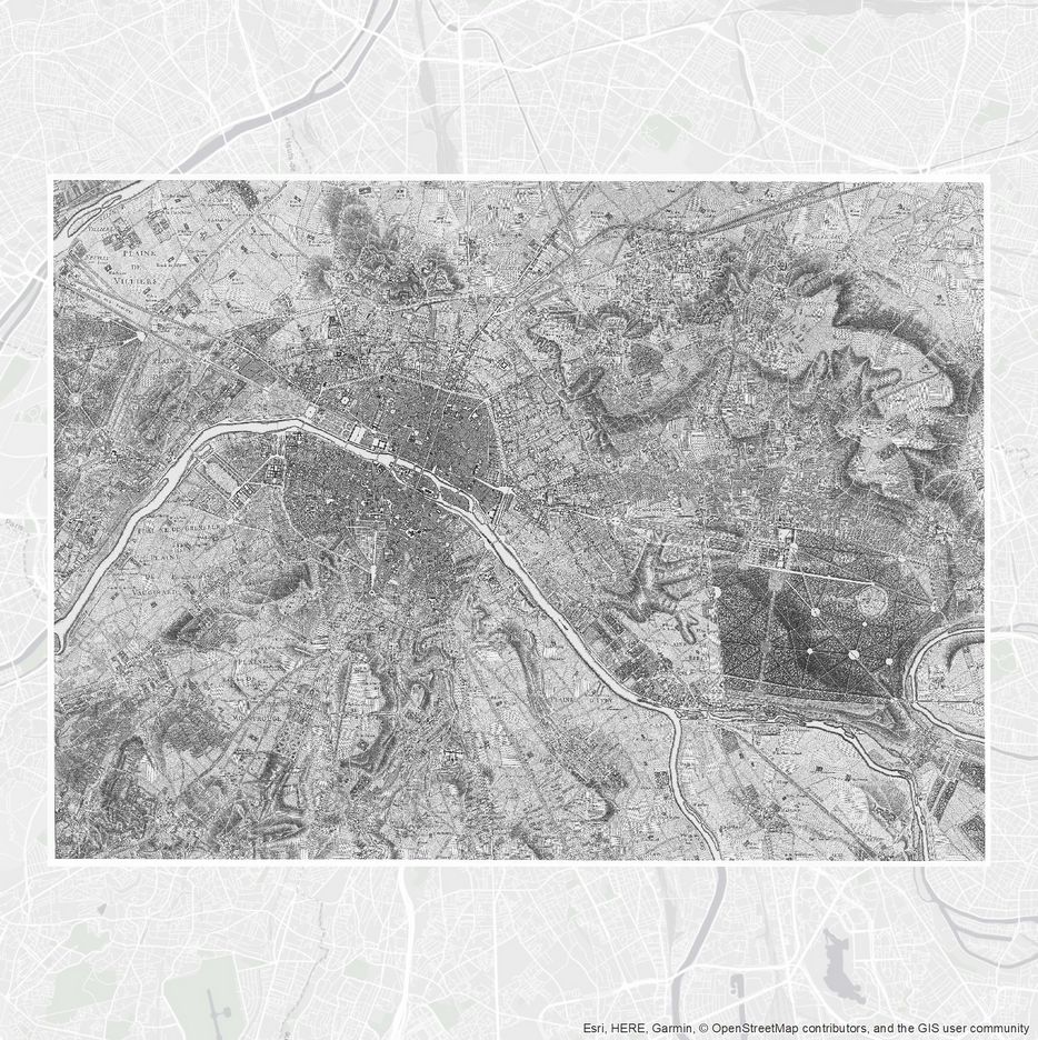
CARTE DES CHASSES DU ROI PARIS ET ENVIRON 1764
La Carte des chasses du roi ou plus exactement la Carte Topographique des Environs de Versailles ou des Chasses Impériales représente une grande partie des territoires de l'Île-de-France au sud de la Seine.
Cette carte de 1764 couvre la Paris, le bois de Vincennes et une partie du bois de Boulogne. Elle est accessible au format ECW et dans une projection RGF93 Lambert 93 (EPSG:2154).
Pour plus de précision sur les plans anciens de Paris et de la Métropole, voir l'application interactive "Cassini | Grand Paris, les plans historiques de 1728 à nos jours" : https://www.apur.org/fr/geo-data/cassini-grand-paris-plans-historiques-1728-nos-jours
Simple
Information de l'identification
- Date (Création)
- 1764
- Etat
- Finalisé
- Contact pour la ressource
-
Rôle Organisation Adresse e-mail Point de contact Apur data@apur.org
- Type de représentation spatiale
- Vecteur
- Catégorie ISO
-
- Carte de référence de la couverture terrestre
Étendue
N
S
E
W
))
- Thèmes de l'Apur
-
- Histoire et patrimoine
- GEMET
-
- histoire
Contraintes sur la ressource
- Limitation d'utilisation
- Données ouvertes
- Limitation d'utilisation
- Licence ODbL
- Contraintes d'accès
- Droit d’auteur / Droit moral (copyright)
- Contraintes d'utilisation
- Licence
- Langue
- Français
- Encodage de caractères
- Utf8
Informations sur la distribution
Ressource en ligne
- Protocole
- FILE:GEO
- Nom
- Chasses_de_l_empereur_1764_Paris_et_environs.ecw
- Fonction
- Information
Informations sur la qualité des données
- Niveau
- Carte
Généalogie des ressources
- Niveau
- Carte
Information sur la représentation spatiale
- mri:geometricObjectType
Information sur le système de référence
- Nom du système de référence
- RGF93 Lambert 93 (EPSG:2154)
Métadonnées
- Identifiant de la fiche
- urn:uuid/b806dac0-1aa6-42d8-8d9d-787155e89b74
- Langue
- Français
- Encodage de caractères
- Utf8
- Point de contact des métadonnées
-
Rôle Organisation Adresse e-mail Point de contact Apur data@apur.org
Type de ressource
- Domaine d’application de la ressource
- Carte
- Lien vers la métadonnée
- https://geocatalogue.apur.org/catalogue/srv/fre//metadata/b806dac0-1aa6-42d8-8d9d-787155e89b74
- Informations de date (Révision)
- 2021-03-03T10:19:59
- Informations de date (Création)
- 2018-09-28T23:09:57
Norme des métadonnées
- Titre
- ISO 19115:2003/19139
- Edition
- 1.0